WEATHER ALERT | Saturday, Oct. 10, 2026 | 10:30 a.m. PDT
Residents of Fallbrook, Bonsall, Rainbow, De Luz and surrounding rural communities, along with portions of Southwest Riverside County, are urged to prepare for potentially dangerous weather, particularly in low-lying areas, along creeks and streams, and on rural roads susceptible to flooding.
The National Weather Service in San Diego said the storm is expected to approach northern Baja California or Southern California late Saturday night or early Sunday, Oct. 11. The exact track remains uncertain, and a shift farther north could increase rainfall and wind impacts across San Diego County.
Flood Watch in effect Saturday evening through Sunday evening
The National Weather Service warns that excessive rainfall could cause flooding of rivers, creeks, streams, drainage channels and other flood-prone areas.
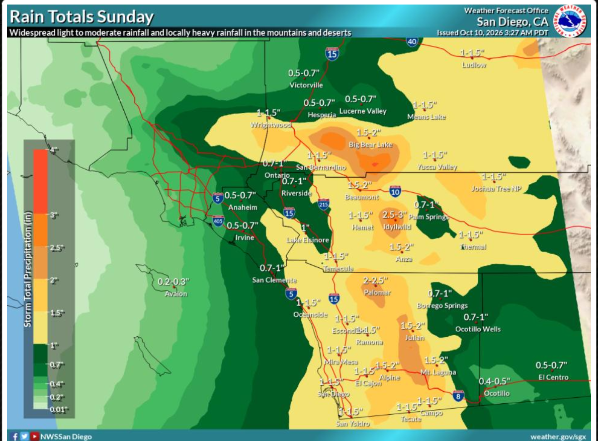
Forecast rainfall – San Diego inland valleys 1–3 inches
Possible peak rainfall rate – valleys 0.5–0.6 in/hr
Possible peak rainfall rate – mountains 0.7–1 in/hr
National Weather Service forecast and alert information. Amounts vary by location; locally higher rainfall is possible. The heaviest rainfall is expected late Saturday night through Sunday afternoon, with additional showers possible Monday and Tuesday, according to the National Weather Service.
In Fallbrook, Bonsall and Rainbow, rapidly accumulating rainfall could cause flooding along low-water crossings, rural roads and drainage channels. Residents near the Santa Margarita River, San Luis Rey River and their tributaries should be particularly alert to rising water.
Areas of De Luz, Rainbow and the surrounding hillsides could also experience erosion, mudslides, falling rocks and debris washing onto roads during intense rainfall.
Strong winds could bring down trees and power lines. The Tropical Storm Watch means sustained winds of 39 to 73 mph are possible within the watch area, although current forecasts for San Diego County’s inland valleys call for substantially lower winds.
The National Weather Service’s local forecast calls for peak winds of 10 to 15 mph with gusts to 30 mph in the inland valleys, while accounting for the possibility of stronger tropical storm-force winds if the storm’s track changes.
Possible impacts include broken tree limbs, downed fences, flying debris, blocked roads and scattered electrical outages.
Residents should secure patio furniture, trash containers, outdoor decorations and other loose objects before winds increase.
Southwest Riverside County also faces storm impacts
Residents of Temecula, Murrieta, Menifee, Wildomar, Lake Elsinore and surrounding communities should prepare for rain, gusty conditions and possible localized flooding.
Although the National Weather Service’s Flood Watch does not currently include every Southwest Riverside County valley community, the Riverside County mountains are included, and heavy rainfall could create dangerous runoff in washes, drainage channels and low-lying areas.
Motorists traveling Interstate 15, Interstate 215, state Route 76, state Route 79 and rural roads should remain alert for standing water, reduced visibility, fallen debris and sudden road closures.
Residents urged to prepare now
The National Weather Service recommends that residents monitor forecasts and be prepared to act if flood warnings are issued.
Residents in flood-prone areas should consider moving vehicles and valuable belongings to higher ground, clearing drainage areas where safe, charging phones and emergency equipment, and preparing for possible power outages.
Drivers should never attempt to cross flooded roads. Even relatively shallow moving water can sweep vehicles away.
Residents should also avoid entering creeks, flood-control channels and riverbeds during the storm, even if those areas appear dry before rainfall begins.
A Flood Watch means flooding is possible, while a Flood Warning means flooding is occurring or imminent. A Tropical Storm Watch similarly indicates that tropical storm conditions are possible, not guaranteed.
The National Weather Service emphasizes that Rachel’s track and intensity remain uncertain and that conditions could change rapidly.
Residents can obtain updated warnings at weather.gov/sgx and emergency preparedness information at SDCountyEmergency.com.
Sources: National Weather Service San Diego forecast discussion, tropical storm statements and flood watches issued Oct. 9–10, 2026. This is a locally adapted news advisory, not an official NWS-issued warning.
_______________________________________________________________________
📢 NEW SANDBAG LOCATION
A new county location is available for district residents to pick up sand and sandbags.
📍 Horse Creek Ridge Staging Area, across the street from 5090 CA-76 in Fallbrook.
Please share with neighbors and stay safe!
The National Weather Service has issued a Tropical Storm Watch for San Diego County and a Flood Watch for portions of Southern California as Tropical Storm Rachel approaches the region, threatening to bring heavy rainfall, dangerous flooding, strong winds and hazardous travel conditions Saturday night through Sunday.
——————————–
## Free sandbag locations in Southwest Riverside County
STORM PREPARATION | Saturday, Oct. 10, 2026
Residents preparing for Tropical Storm Rachel can obtain free sandbags at several locations throughout Southwest Riverside County. Most locations require residents to fill their own bags, and supplies may be limited.
### Temecula
The City of Temecula provides up to 10 free sandbags per household or business, available from 7 a.m. to 8 p.m. at these fire stations:
– Station 12 – 28330 Mercedes St.
– Station 73 – 27415 Enterprise Circle West
– Station 84 – 30650 Pauba Road
– Station 92 – 32211 Wolf Valley Road
– Station 95 – 32131 South Loop Road
Free sand is available at three locations:
– Ynez Road and Santiago Road
– Meadows Parkway and La Serena Way
– Patricia H. Birdsall Sports Park, east parking lots
Residents should bring shovels and fill their own bags.
[image](https://www.google.com/s2/favicons?domain=https://temeculaca.gov\&sz=32)
Temecula CA
### Murrieta
Murrieta Fire & Rescue announced Friday, Oct. 9, that residents can obtain up to 10 free sandbags per household at:
Fire Station 2 – 40060 California Oaks Road
The bags are available to Murrieta residents, who must fill them themselves.
The city has also previously designated Fire Station 1, 41825 Juniper St., and the Municipal Services Department yard at Fig Street and Jefferson Avenue as storm preparation locations, although availability at those two sites for this weekend has not been confirmed.
### Lake Elsinore
The City of Lake Elsinore lists free sandbags at:
Public Works Yard – 521 N. Langstaff St.
Additional county-designated sand locations include:
– Lakeland Village Fire Station 11 – 33020 Maiden Lane
– El Cariso Picnic Site – 32405 Ortega Highway, across from Fire Station 51
Sand availability is limited;
[image](https://www.google.com/s2/favicons?domain=https://www.lake-elsinore.org\&sz=32)
Lake Elsinore, CA
### Menifee
The city has designated these self-service sandbag locations:
– Fire Station 5 – 28971 Goetz Road
– Fire Station 7 – 28349 Bradley Road (empty bags only)
– Fire Station 68 – 26020 Wickerd Road
– Fire Station 76 – 29950 Menifee Road
– Public Works Maintenance Center – 27860 Bradley Road
Previously published hours are 7 a.m. to 7 p.m. at fire stations and 7 a.m. to 3 p.m. at Public Works. These locations and hours are based on earlier city notices, so availability for this weekend should be confirmed;
[image](https://www.google.com/s2/favicons?domain=https://www.cityofmenifee.us\&sz=32)
City of Menifee
### Wildomar
Wildomar Cemetery – 21400 Palomar St., entrance on Gruwell Street.
The city lists up to 20 free, prefilled sandbags per household for Wildomar residents, with identification required.
– Hours: Monday through Friday, 8 a.m. to 3 p.m.
– Closed weekends and city holidays.
– Information: 951-677-7751, ext. 210.
This site is not listed as open this weekend. 
All groups
Important for publication: The Murrieta announcement is dated Oct. 9, 2026. The other locations are documented in municipal or county resources, but their supply levels and weekend availability have not all been independently verified for this storm. Residents should check before traveling, especially since many locations require a shovel and do not provide prefilled bags.
For updated county information, visit [Riverside County Emergency Management](https://emd.rivco.gov/disaster-preparedness/have-plan/storms).