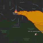
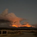
Thursday, August 1 photo of the Nixon Fire area. Firefighters have a 14% containment of the Fire that has burned almost 5200 acres.
Fire coverage area as of 7/31/24 7:30 am
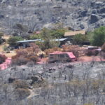
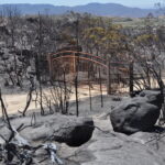
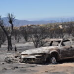
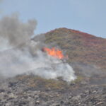
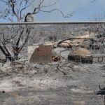
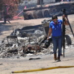
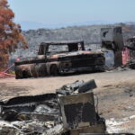
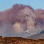
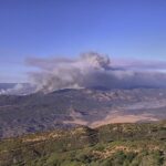
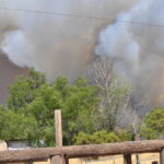
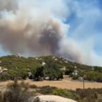
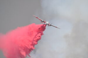
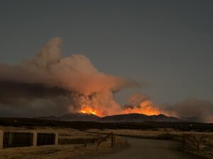
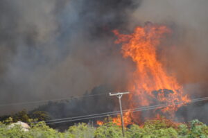
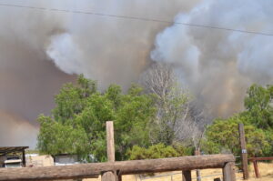
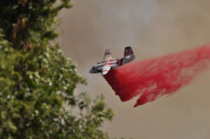
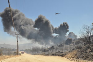
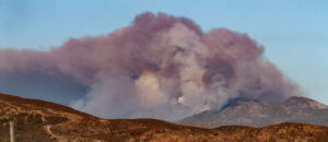
Nixon Fire photo gallery from 7/30/24
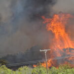
Nixon Fire photo gallery from 7/30/24
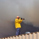
Nixon Fire photo gallery from 7/30/24
Nixon Fire photo gallery from 7/30/24
Nixon Fire photo gallery from 7/30/24
Nixon Fire photo gallery from 7/30/24
Nixon Fire photo gallery from 7/30/24
Nixon Fire photo gallery from 7/30/24
Nixon Fire photo gallery from 7/30/24
Nixon Fire photo gallery from 7/30/24
Nixon Fire photo gallery from 7/30/24
Nixon Fire photo gallery from 7/30/24
Nixon Fire photo gallery from 7/30/24
Nixon Fire photo gallery from 7/30/24
Nixon Fire taken from Cahuilla Monday night about 7:30 pm. Valley News/Brian Briggs photo
Valley News/Diane Sieker photo
The Nixon Fire has burned 3750 acres with zero containment. Valley News/Diane Sieker photo
Valley News/Diane Sieker photo
Valley News/Diane Sieker photo
Nixon Fire burns 2750 acres. Valley News/Shane Gibson photo
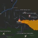
A screenshot of Cal Fire map showing air support for Nixon Fire.
Valley News/Diane Sieker photo
FILE Photo: Valley News/Diane Sieker photo
Valley News/Diane Sieker photo
Valley News/Diane Sieker photo
Valley News/Diane Sieker photo
Nixon Fire balloons to 2750 acres with 0 % containment.
Nixon Fire photo. 131 acres burned. Photo taken by Murrieta firefighters who are on their way to fight the fire.
Valley News/Diane Sieker photo
The Nixon Fire has burned 3750 acres with zero containment. Valley News/Diane Sieker photoThe Nixon Fire has burned 3750 acres with zero containment. Valley News/Diane Sieker photoThe Nixon Fire has burned 3750 acres with zero containment. Valley News/Diane Sieker photoThe Nixon Fire has burned 3750 acres with zero containment. Valley News/Diane Sieker photoThe Nixon Fire has burned 3750 acres with zero containment. Valley News/Diane Sieker photoThe Nixon Fire has burned 3750 acres with zero containment. Valley News/Diane Sieker photo
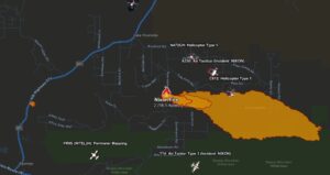
A screenshot of Cal Fire map showing area affected and air support for Nixon Fire.
Status Update: Friday Aug 2- 5222 acres and 21% containment.
Status Update as of 8:15 am on Thursday, August 1, 2024. Cal Fire is reporting that they were able to hold the acres burned to 5192 with 14% containment.
Status Update as of 8 pm Wed, 7-31-24
Situation Summary
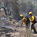
The Nixon fire experienced moderate weather throughout the day. Crews continue to go direct with handline construction and hose lays on the southeast portion of the fire towards the Beauty Mountain Wilderness area. A change in weather patterns may produce lightning and increased wind which could challenge established control lines for the next few days.
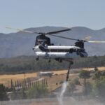
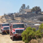
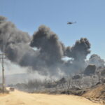
Information from Cal Fire shows the number of firefighters swelled to 797 personnel on Tuesday. There are now 7 helicopters, 69 engines, 9 dozers, 13 water tenders, and 21 crews.
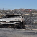
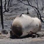
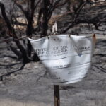
There were four structures damaged and one structure destroyed, according to Cal Fire.
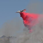
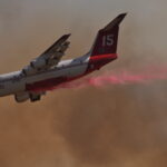
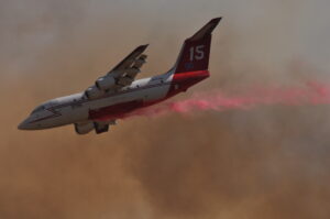
Numerous firefighting air tankers from throughout the State are flying fire suppression missions as conditions allow.
Status Update according to Cal Fire
Situation Summary
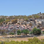
The Nixon fire displayed moderate fire activity and continued to burn to the south and east, adjacent to the San Diego County line and the Beauty Mountain Wilderness in steep and rugged terrain. Firefighters will continue to work throughout the night within the fire’s footprint, focusing on building direct line and improving containment while maintaining structure defense to safeguard the residents of Aguanga. All evacuation orders and warnings will remain in place. Evacuation warnings have also been placed in San Diego County.
Evacuation Orders have expanded into San Diego County
The Nixon Fire has rapidly expanded to 4941 acres by 5:45 pm on Tuesday, after charring 4500 acres by 2:45 pm. It still remains completely uncontained, authorities said. The blaze, which began around 12:30 p.m. near Tule Valley Road and Richard Nixon Boulevard in Aguanga, has led to widespread evacuation orders and warnings as it continues to spread swiftly.
Cal Fire and cooperating agencies, including the Cahuilla Fire Department and Murrieta Fire Department, have deployed significant resources to combat the fire. As of 6:45 p.m., 255 personnel were on the scene, utilizing 44 engines, 8 hand crews, 3 water tenders, 2 helicopters, 2 dozers, and two air tankers along with an air tactical plane.
Evacuation orders have been issued for multiple zones, including:
🚨 All EVACUATION ORDERS and WARNINGS remain in place. For a searchable map of the evacuation areas, visit: http://linktr.ee/calfirerru
🔴 EVACUATION ORDER AREA: Zones RVC-TULE2-A, RVC-TULE2-B, RVC-TULE4, RVC-TULE6, RVC-TULE7, RVC-TULE8, CBI-CAHUILLA1-B, RVC-2327-A, RVC-2327-B, RVC-TABLEMT4, RVC-TABLEMT5, RVC-2369.
Residents in these areas are urged to leave immediately, with reception and care services set up at Temecula Valley High School, located at 31555 Rancho Vista Road. Animal services are also available at the site to assist evacuees with pets.
The evacuation area is bounded by Spanish Spur Trail to the north, Trailmaster Drive to the west, Barbara Trail to the east, and Highway 371 to the south. An evacuation warning is also in place for areas north of the San Diego/Riverside County Line, south of Heller Springs Road, east of Terwilliger Road, and west of Table Mountain Truck Trail.
The Nixon Fire’s cause remains under investigation. As the situation develops, residents are advised to stay updated through official channels and to heed evacuation orders and warnings to ensure their safety.
________________________________________
UPDATE 9:30 p.m. – The fire is now 3,700 acres and remains 0% contained. All evacuation orders and warnings will remain in place.
UPDATE: As of 6:45 there are 2750 acres burned. There are now 255 personnel fighting the Nixon Fire.
UPDATE: As of 5:30 pm the Nixon Fire has burned 1000 acres with zero containment and continues to spread rapidly. There are now 44 engines working the fire, 8 hand crews, 3 water tenders, 2 helicopters, 2 dozers, and there appear to be two air tankers and one air tactical plane.
Nixon Fire burns 2750 acres. Valley News/Shane Gibson photo
Alert RivCO: An evacuation order is in place for the Nixon Fire. It is located North of Spanish Spur Tr, East of Barbara Trl, West of Trailmaster Dr., and South of HWY 371. Reception and care will be at Temecula Valley High School 31555 Rancho Vista Rd. Animal Services will be at reception and care.
Immediate threat to life. This is a lawful order to leave now. The area is lawfully closed to
Evacuation orders have been issued as the Nixon Fire continues to spread rapidly in Riverside County. According to a Cal Fire update at 3:04 p.m., the fire has consumed 295 acres. The evacuation orders affect areas east of Tule Peak Road, north of Sunset, south of Richard Nixon Blvd., encompassing zones RVC-TULE2-A, RVC-TULE2-B, RVC-TULE4, RVC-TULE6, and CBI-CAHUILLA1-B. The specific boundaries for the evacuation area are north of Spanish Spur Trail, west of Trailmaster Drive, east of Barbara Trail, and south of Highway 371.
A care and reception center has been established at Temecula Valley High School, located at 31555 Rancho Vista Road, Temecula. Animal services will also be available on-site to assist evacuees with pets.
The Nixon Fire, which ignited around 12:30 p.m. near Tule Valley Road and Richard Nixon Blvd. in Aguanga, was initially reported to have burned 131 acres by 2:18 p.m. The fire is advancing at a moderate to rapid pace, and its cause remains under investigation.
Cal Fire has deployed 24 engines, 3 water tenders, 2 helicopters, 2 dozers, 4 hand crews, and a total of 205 personnel to combat the blaze. The agency responded to multiple reports of the vegetation fire and requested additional air resources shortly after the fire was reported.
Cooperating agencies involved are: Cahuilla Fire Department; CAL FIRE San Diego; Murrieta Fire Department.
Residents in the affected zones are urged to evacuate immediately and stay informed through official channels for further updates.
_________________________
EARLY VERSION BREAKING NEWS:
3:04 pm Cal Fire update: 295 acres have now burned in Nixon Fire.
EVACUATION ORDERS
Evacuation ORDERS are in place for the following area:
EVACUATION ORDER AREA: Zones RVC-TULE2-A, RVC-TULE2-B, RVC-TULE4, RVC-TULE6, RVC-TULE7, RVC-TULE8, CBI-CAHUILLA1-B, RVC-2327-A, RVC-2327-B, RVC-TABLEMT4, RVC-TABLEMT5, RVC-2369.
The care and reception center for evacuated residents is at Temecula Valley High School, 31555 Rancho Vista Road, Temecula. Animal services will be on-site at the location to assist with animals
BREAKING: A wildfire dubbed the Nixon Fire started in the Aguanga area at about 12:30 pm today. As of 2:18 pm, there were 131 acres burned in the area of Tule Valley Road and Richard Nixon Blvd. in Aguanga. The fire was reported to be moving at a moderate to a rapid rate of spread. The cause is unknown at this time.
Resources in use: There are 24 engines, 3 water tenders, 2 helicopters, 2 dozers, 4 hand crews, and 205 total personnel fighting the fire, according to Cal Fire.
Original post from Cal Fire: VEGETATION FIRE – Reported at 12:28 p.m. in the area of Tule Valley Road x Richard Nixon Boulevard in Aguanga. Firefighters responded to multiple reports of a vegetation fire. The first on-scene engine reported approximately 5 acres of vegetation burning with a moderate to a rapid rate of spread. Additional air resources have been requested.


